To date, no deeds, warrants, or surveys for land have been
found for Edmond Lindsey in the Fort Pitt area. But it
is known from a 1778
deposition that
Edmond Lindsey lived on Mounts Creek, about 4 miles above the
Youghiogheny River on land that he had purchased from the
Pennsylvania government. Additionally, Edmond Lindsey
paid taxes on land in Tyrone Township in 1783 (see
timeline
for source).The description of Edmond
Lindsey's land in the deposition places him in on the border
of Bullskin Township and Upper Tyrone Township of present day
Fayette County. This would have been Tyrone Township in
Westmoreland County in 1778. I have used a township
warrantee map of Upper Tyrone for this study, but the township
warrantee map of Bullskin also shows the same landowners.
In a 1778
deposition, Edmond Lindsey stated that he lived on Mounts
Creek about 4 miles above the Youghiogheny River, when he was
forcefully taken to Col. John Stephenson's house, where he was
placed as a prisoner in Col. Stephenson's meat house.
Edmond stated that he was next taken to Stewart's Crossing,
about 3 miles away.
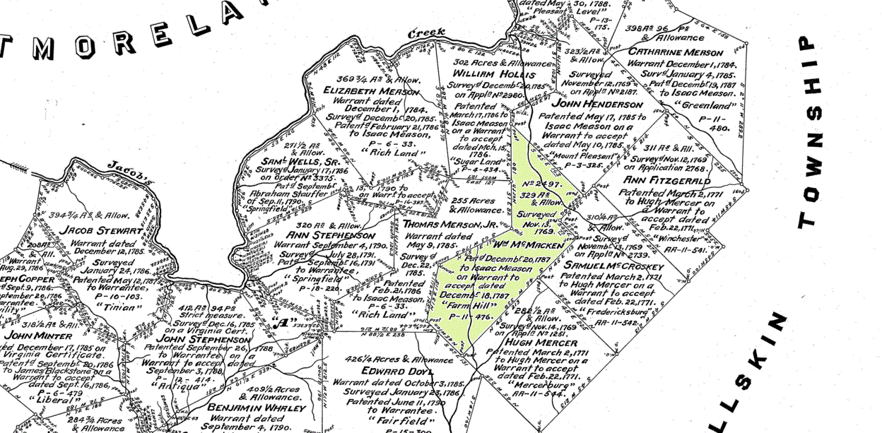
The township warrantee map, below, shows the location of Col.
John Stephenson's land in Upper Tyrone Township in present day
Fayette County, Pennsylvania. Edmond Lindsey is not
listed on the map as a landowner, but he paid taxes on land in
Westmoreland County (Fayette formed from Westmoreland in 1784)
in 1783. Col. John Stephenson's land was about 3 miles above
Stewart's Crossing (Stewart's Crossing was on the Youghiogheny
River).
The warrantee map shows that Samuel Wells
and Edward Doyl (Doyle) were nearby landowners. Samuel
Wells and Edward Doyle interacted with Edmond Lindsey in a
number of records (see
timeline),
so it seems that Edmond Lindsey might have lived near these
two men. Samuel Wells also made a deposition in 1778
that he was forcefully taken to Col. John Stephenson's house.
Edmond Rice, who is not shown on the landowner's map, was also
an associate of Edmond Lindsey (see
timeline),
and Edmond Rice also made a 1778 deposition about being taken
to Col. Stephenson's house. Edmond Rice had purchased
the
Jacob Stewart tract on Jacob's Creek from John Stephenson
in 1773 (Westmoreland Co., PA Deed Book A, Page 292), so it is
likely that Edmond Rice also lived in the neighborhood shown
below on the warrantee map.
It is my guess that Edmond Lindsey lived on
the William McMacken tract, below. The
warrant application for Thomas Meason Jr.'s survey listed
Edward Lindsey as an adjoining neighbor, along with Edward
Doyle, John Stephenson, Valentine Crawford, deceased, and
Samuel Irvine. Other than Edward Doyle's tract and the
McMacken tract, all the properties that border Meason's land
were on Jacob's Creek. Because Edmond Lindsey stated
that he had purchased property on the waters of Mounts' Creek,
and not Jacob's Creek, it seems he most likely lived on the
McMacken property. Map source: Early Landowners of
Pennsylvania: Fayette Co. Patent Maps, CD by
Ancestor Tracks.
|